Trip Length: 25 Days
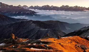
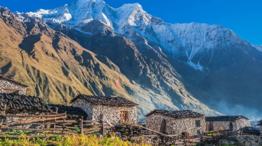
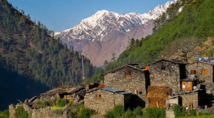
Enquiry NowThe Tsum Valley, also known as the Hidden Valley a land of monasteries and hamlets with totally Tibetan population lies on the northern part of Manaslu on the Nepal-Tibet border and used to be a restricted area until 2008. Although the region lies within Nepal, the Buddhism influenced region is a world of its own. Traditionally, Tsum used to be a separate area different from both Nepal and Tibet. The Tsum Valley region is still less exposed in comparison to other tourist areas, with relatively virgin and less beaten paths in comparison to the more popular regions. The Tsum people have their own way of family life, which may be quite surprising for many outsiders. All the brothers in the family are married to a single girl, what you may call a practice of polyandry. Compared with other areas, The Tsum Valley and Manaslu area is full of imminent mountains, passes, deep gorges, hamlets, gompas, chortens, and mani walls.
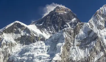
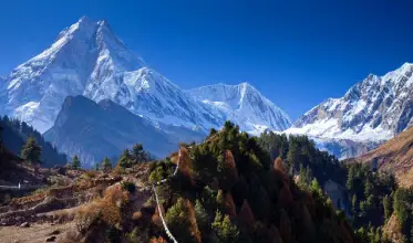
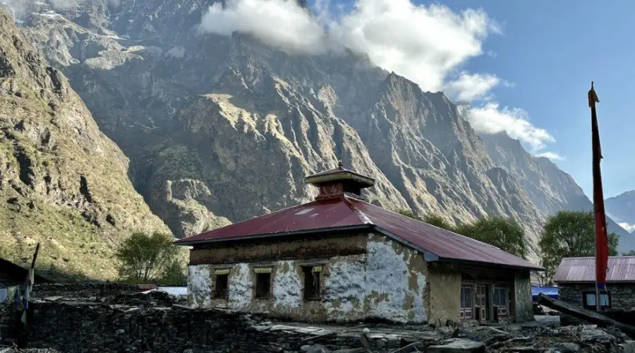
The trek to Tsum Valley takes you into the majestic surroundings of the Ganesh Himal, Sringi Himal, and Boudha Himal ranges. In the initial days of the trek, we explore the Budhi Gandaki Valley through a mix of dense forest, terraced fields and hill villages. As we leave the main Manaslu Trail for the Tsum valley, suddenly we get a feeling of entering truly into the hidden valley. While on the trek, we also pass through the alpine forests, glacial rivers, and enjoy the warm hospitality of ethnic people. We also visit the ancient Buddhist Gombas of the region including the Milarepa's Cave, Rachen gompa, Mu Gompa among others.
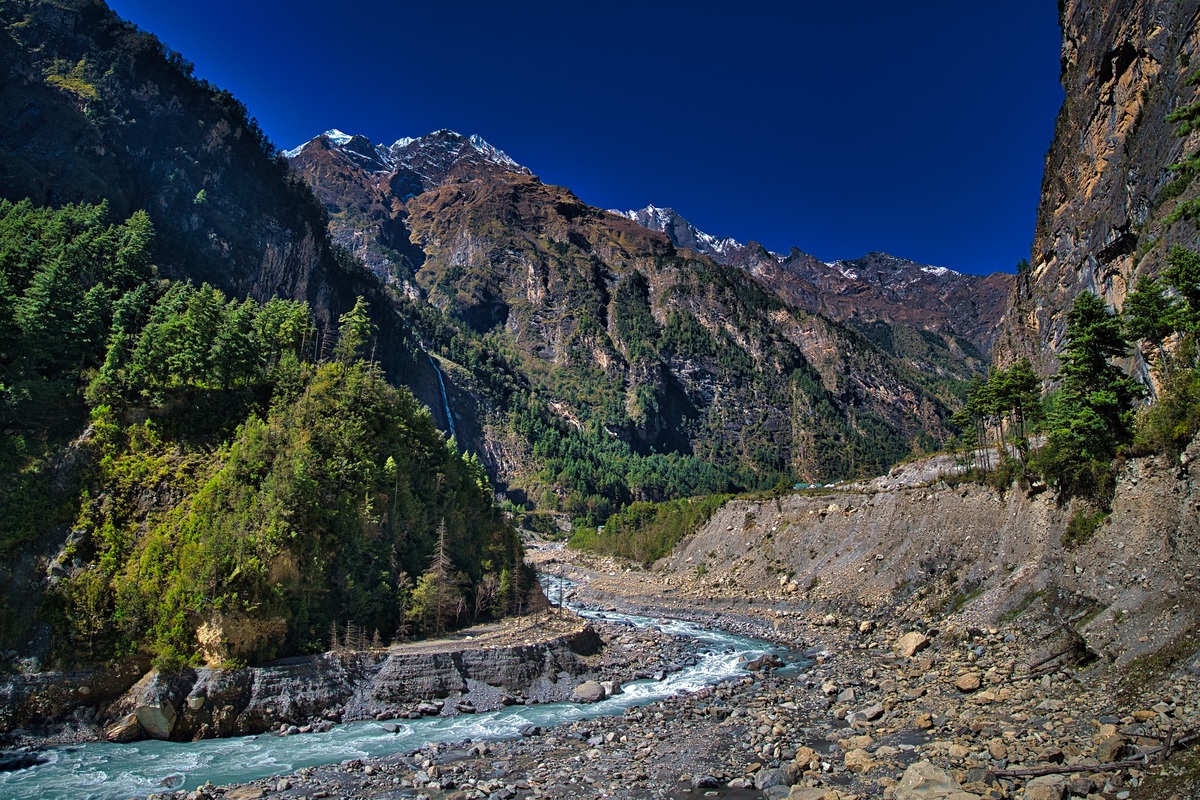
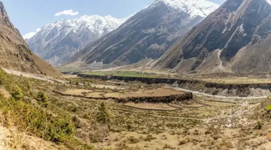
The Tsum Valley is recently opened restricted area for trekking in northern Gorkha. It is a popular hidden valley ringed by the Baudha Himal and Himal Chuli to the west, Ganesh Himal to the South and Sringi Himal to the north. The Valley is bounded by three high passes – the Ngula Dhoj Hyang (5093 m.) to the west and Yamdro Pass (5326m.) to the north. Trails are strewn with artistic chortens and lined with mani walls carried with drawings of deities and inscribed with prayers. The local people are of Tibetan origin and practice Bon religion. The trek starts at Arughat and the trail follows the winding Budi Gandaki river until it reaches the first elevated Tsum Valley with magnificent vistas of the Ganesh Himal and other surrounding peaks.
| Max Altitude | Dharapani(1860m) |
|---|---|
| Difficulty | Strenous |
| Best Season | All Year |
| Accommodation | Hotels |
We take an 8-9 hrs bus ride to Arughat Bazaar in Gorkha district. The village of Arughat is in two parts, on opposite sides of the Buri Gandaki. Arughat Bazaar is large, clean and prosperous with hotels and shops selling cloth, food and hardware. We drive further to Sotikhola
We trek from Soti Khola to Machha khola (Fish river). Machha khola is a village situated above a stream with the same name. We camp for the night by a wide campsite.
The trail from Macha Khola to Doban involves some steep ascents and descents. We climb a well – crafted staircase over a ridge to Doban. Doban lies at the confluence of the Shiar Khola, which flows from the east, and the Sarpu khola, which flows from the west.
The route climbs ona rugged rocky trail. We climb up and down ravines and notched trees. We get good views of Sringri himal as we continue up to the village of Philim at 1550m.This is a large Gurung village with fields of corn and millet. There are several good campsites and we set up camp surrounded by alder, blue pine and poplar trees.
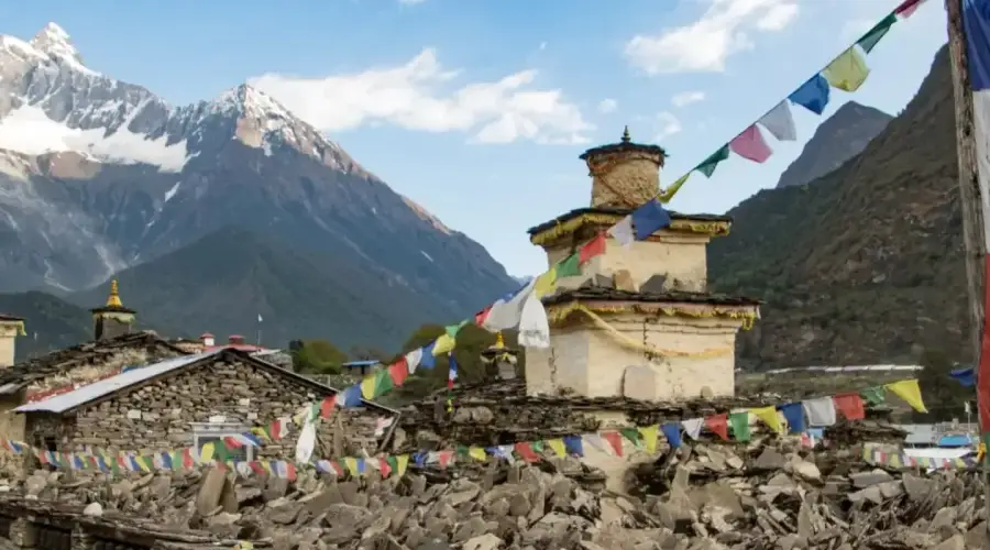
Walk past Philim to the north across a forest with the views of the narrowing valley. After Ekle Bhatti cross the gorge, and enter the pine tree forests. Descend down to trail going to the Tsum Valley. Climb through pine and rhododendron forests. Enjoy the views of Himalchuli mountains. Pass Lokpa, climbing further north through pines and rhododendrons. Climb down to Ghumlong, and climbing up to Ripchet. Crossing the Shiar Khola, finally arrive at Chumling. Visit the old Chumling gompa, and the stone streets of the village
Cross the suspension bridge onto the opposite bank. Enjoy the great views of Ganesh Himal. Walk past Rainjham to Serpu Khola. Now we enter the hidden valley of Tsum. Another steep climb takes us to the village of Chhokangparo. Weather permitting, enjoy the views of Himalchuli at 7893 meters.
While climbing above Chokhangparo, better to be careful of altitude problems. Walk past Lamagaon to the Rachen Gompa. Climb up to the Milarepa’s Cave. Then we cross the Shiar Khola. Continue walking through the villages of Phurbe and Pangdun. After crossing the village of Chhule, climb upstream and cross the bridge to finally arrive at Nile.
We are now almost close to the Tibetan border. Walk to the west bank of the valley through the Tibetan landscapes. Climb up to the Mu Gompa. From Mu Gompa, climb further up to Bhajyo and We are quite close to Tibet and get a good view of the Tibetan peaks as well as the Ganesh Himal range. Bhajyo is a remote area there is not any local houses. Only we can see some yak farm house. After having the lunch we will explore the area.
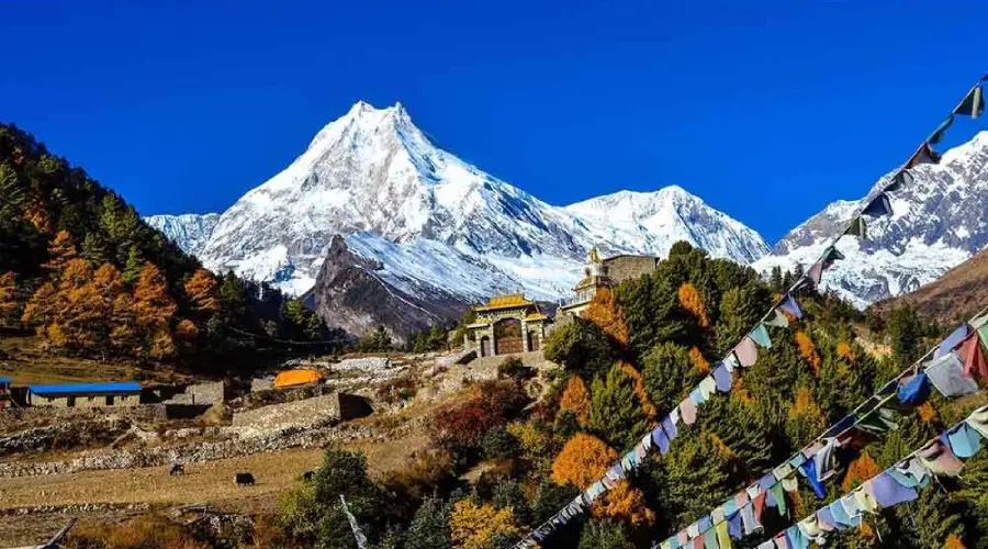
From Bhajyo, we descend down to Rachen Gumba. Established in 1905 AD, the Rachen Gumba is a nunnery in the Shiar Khola Valley. The nunnery is one of largest in the region is of great importance. The interior of the Gumba is splendidly painted with Buddhist mural paintings.
Continue south until a bridge crosses to the west bank then descend again to Chhokangparo. Drop below Chhokangparo on the previous trail for about 2hrs, until a small gompa is reached at Gho (2485m). Then taking the northern route in the lower Tsum Valley, we finally arrive at Chumje via Yaju.
From Chumje, we continue on the northern route in the lower Tsum Valley. Pass the village of Dorjon Kharka just before reaching Rana. Crosss the large suspension bridge in the main valley of the Manaslu Budhi Gandaki River. If interested, walk further up to the village of Bihi.
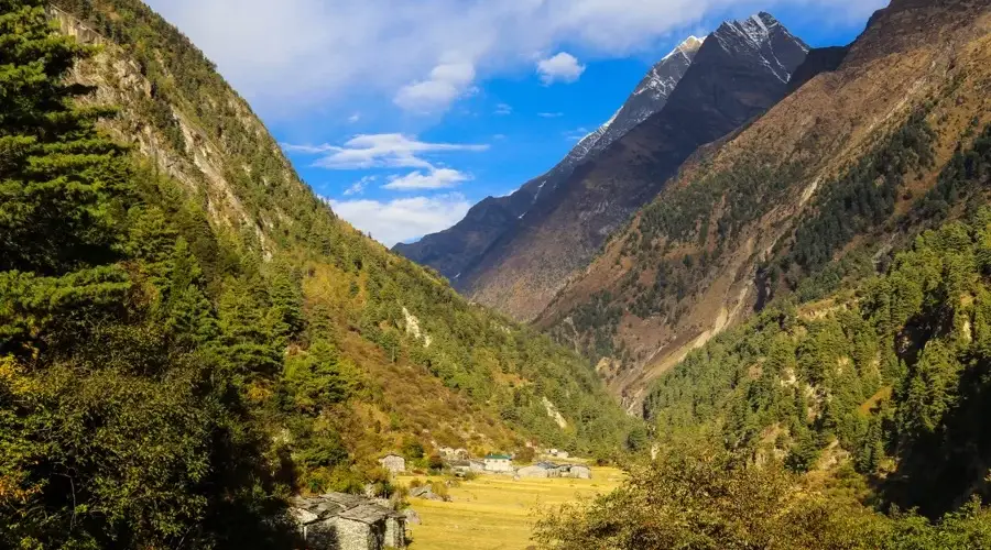
The initial part of today's trek is on a relatively flat terrain. Soon, the trail moves uphill through the forest path. Thus we arrive at Namrung while enjoying at the same time the magnifiscent views of Manaslu, among others.
From Namrung, we again enter the Buddhism influenced region. Climb through the forest to Lihi. Enjoy the spectacular rise of the Ganesh Himal. Descend to Sho. Another steep climb takes us to our today's campsite on a ridge.
The Budi Gandaki is far down but we follow a small tributary instead. Walking in the shady fir forest is very enjoyable. A short climb to a plateau and the village Shyala. Huge mountains surround us, Himal Chuli and Peak 29 (Ngadi Chuli) to the left, Manaslu and large glaciers straight ahead, other snow summits to the right, at the far end of the valley we have just come from stands Ganesh Himal. At the far end of the village, overlooking the valley stands the well-known monastery of Sama. Sama Gaon is a village inhabited mainly by the Tibetans and lies at the foot of Manaslu.
Descend to the Budi Gandaki, that has turned north, and follow it to a bridge over a side stream. The trail to the left leads to the Manaslu Base camp. The Larkya la Trail passes several mani walls as the valley begins to widen. It is an easy trail on a shelf above the river passing the juniper and birch forests of Kermo Kharka. We drop off the shelf, cross the Budhi Gandaki on a wooden bridge and climb steeply onto a promontory between two forks of the river. From a stone arch we can see a large white kani, finally passing through the kani we find Samdo.
We continue our walk down the edge, cross the wooden bridge over Budi Gandaki and begin walking upward. Cross two streams and witness the Larkya Glacier. Go around the valley of the Salka Khola and climb up again and come to the stone guest house (4450 m) which is not a lodge but a kind of shelter called Dharmshala, also known as Larkya Phedi. We camp here today and have a rest to prepare for tomorrow's crossing of the famous and most awaited Larkya Pass. After a short climb, we reach the ablation valley on the North side of the Larkya Glaciers.
After an early start, we soon walk across the moraines of the glacier, making a gradual ascent which becomes steeper only in the last section to the pass. From the pass, there are outstanding views of Himlung Himal, Cheo Himal, Kangguru and the huge Annapurna II. Savor the spectacular views from the top of the pass. It is a longer day then usual to Bimtang, but to walk into these low pastures with the evening mist coming in and Manaslu; it's an experience not to be missed.
We have been trekking incessantly for more than 2 weeks. Still one more week to trek in the mountains. Therefore, a rest day would prove a blessing for the tired muscles. Also discover the area surrounding Bimthang as well the cultural life of the mountain people.
We will descend a great height today. Initially, from the valley of Burdin Khola, through rhododendron forests, to Karche, the highest cultivating place in the valley. Then we descend to the village of Gho. While staying on the north bank of the river, we trek into Tilje. Leave the Tilje Village, and cross the Dudh Khola. Cross a wooden bridge back to the northern side of the Dudh Khola. Continue to Dharapani.
The remainder of our trek follows trails used on the first few days of the Annapurna Circuit Trek. We descend to the Marsyandi River and cross the suspension bridge. Climb up and away from the river and hike through a broad, flat valley to the village of Tal (1,675m), situated at the foot of a large waterfall.
The trail continues on to Chyamje. From Chyamje, trekking up and down along the river, we reach Jagat. A steep trail descends from Jagat through the Marshyangdi valley. Cross Marshyangdi River at Syange and walk to Ghermu.
The Marsyandi valley opens and on its banks terrace fields and villages clung very high to the hillsides are the age-old work of the Nepalese farmers. We cross several interesting villages such as Bhulbhule, Khudi, etc. Then we walk on a flat part alongside the left bank of the Marsyandi. A last walk up for reaching Besi Sahar, a dusty and busy place which marks the end of our trek and the beginning of the civilization.
A 7 to 8 hours' of picturesque drive on the way back to Kathmandu along the banks of the Marsyangdi and Trishuli rivers with splendid views of green hills, mountains, farming terraces and villages on both sides of road.